Products
Created Monday 24 July 2017
There are different data products associated with the three levels of processing of OLCI:
Level-0 is the reconstructed and time-sorted Instrument Source Packet (ISP) at full space-time resolution. All communications artefacts (e.g. synchronisation frames, communications headers and duplicate data) and invalid packets are removed. OLCI data is always sensed in full resolution mode (300 m resolution).
Level-1 includes Top-Of-Atmosphere (TOA) radiometric measurements, radiometrically corrected, calibrated and spectrally characterised. It is quality controlled, ortho-geolocated (latitude and longitude coordinates, altitude) and annotated with satellite position and pointing, landmarks and preliminary pixel classification (e.g. land/water/cloud masks). Products are generated in FR (300 m) and in RR (1.2 km) for the whole globe with the same coverage.
Level-2 products consist of geophysical quantities derived from the processing of measurement data provided in the Level-1 product. Level-2 products specifically for marine and land application domains are generated separately by the SENTINEL-3 PDGS, with each containing the parameter relevant for the specific field of application. Level-2 atmospheric information relevant for both application domains, such as water vapour, is reported in both data streams.
OLCI Level-1 and 2 data products are available to the general public.
The OLCI files are collected into a SAFE container. Level-1 and 2 products are encapsulated in free-standing NetCDF 4 product files.
The timeframe for delivery of products is dependent on the specific application:
Near Real-Time (NRT) products are delivered to the users less than 3 hours after acquisition of the data by the sensor
Non-Time Critical (NTC) products are delivered not later than 1 month (commitment) after acquisition or from long-term archives. Typically, the product should be available within 24 or 48 hours (but this is not guaranteed).
Ver tambien:
https://sentinel.esa.int/documents/247904/2702575/Sentinel-3-OLCI-level-2-Land-Product-Notice
Land Products
https://sentinel.esa.int/web/sentinel/user-guides/sentinel-3-olci/product-types/level-2-land
Water Products
https://sentinel.esa.int/web/sentinel/user-guides/sentinel-3-olci/product-types/level-2-water
Minimize Level-2 Water WRR and WFR
The OLCI Level-2 water reduced or full resolution products, OL_2_WFR and OL_2_WRR respectively, are outputs from the OLCI Level-2 processor and contain water and atmospheric geophysical products at full and reduced resolution.
The content of these files depends on several switches included in the OLCI configuration parameters. Each geophysical parameter format is only triggered if the corresponding switch is set to '1'. Note that all pixels flagged as cloudy are discarded from OLCI Level-2 processing
The only difference between the OL_2_WFR and OL_2_WRR products is the spatial resolution.
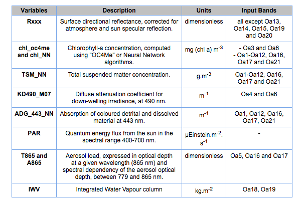
Each product provides, as measurement data files (fully described in the table below):
water-leaving reflectance (Rxxx) for all bands except those dedicated to measurement of atmospheric gas. Two types of reflectance are distinguished: the BAC reflectance for "Baseline Atmospheric Correction algorithm" (MERIS heritage) or AAC reflectance for "Alternative Atmospheric Correction algorithm" (based on a neural network procedure). BAC is used for the operational output of the reflectance in this product package but in cases where reflectances are computed and AAC is needed, a setting has been defined in the configuration file to switch between algorithms.
ocean colour products such as algal pigment (chl_oc4me and chl_nn, in two separated files), Total Suspended Matter (TSM_NN) concentrations and transparency characterisation based on the Diffuse Attenuation coefficient (KD490_M07).
neural network water-inherent optical properties such as CDM absorption (ADG_443_NN).
atmosphere by-products such as Photosynthetically Active Radiation (PAR), Aerosol Optical Depth /Aerosol Angstrom exponent (gathered in one file and noted respectively as T865 and A865) and Integrated Water Vapour (IWV) column. Note that this last variable also contains information for water pixels and is identical to the one included in OL_2_WRR and OL_2_WFR.
error estimates for all the products.
Several associated variables are also provided in the annotations data files:
classification, quality and science flags (WQSF)
common data such as the ortho-geolocation of land pixels, solar and satellite angles, atmospheric and meteorological data, time stamp or instrument information. These variables are inherited from Level-1B products