ProcessingLevels
Created jueves 22 septiembre 2016
http://modis-fire.umd.edu/files/MODIS_Burned_Area_Collection51_User_Guide_3.0.pdf
2.1 Processing Levels (from the EOS data products handbook):
Level 0
Reconstructed unprocessed instrument/payload data at full resolution;
any and all communications artifacts (e.g., synchronization
frames, communications headers) removed.
Level 1A
Reconstructed unprocessed instrument data at full resolution, time
referenced, and annotated with ancillary information, including radiometric and
geometric calibration coefficients and georeferencing par
ameters (e.g., platform ephemeris) computed and appended, but not applied, to the Level 0 data.
Level 1B
Level 1A data that have been processed to sensor units (not all instruments have a Level 1B equivalent).
Level 2
Derived geophysical variables at the same resolution and location as the Level 1 source data.
Level 3
Variables mapped on uniform space time grid scales, usually with some completeness and consistency.
Level 4
Model output or results from analyses of lower level data (e.g., variables derived from multiple measurem
Tb ver http://uregina.ca/piwowarj/Think/ProcessingLevels.html
For Setinel 2 https://sentinel.esa.int/web/sentinel/user-guides/sentinel-2-msi/processing-levels/
- Level 0. package the MSI (instrument) and satellite ancillary raw-data that has been acquired by the Ground Segment and to archive it together with the relevant annotation parameters and other metadata.
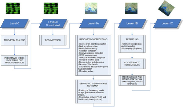
- Level 1
- Level-1A processing is focused on decompressing relevant mission source packets. The Level-1A product is not available to users.
- Level-1B processing uses the Level-1A product and applies the required radiometric corrections. The Level-1B product is not made available.
- Level-1C processing uses the Level-1B product and applies radiometric and geometric corrections (including orthorectification and spatial registration).
- TOA reflectance
- Level-2A processing includes a scene classification and an atmospheric correction applied to Top-Of-Atmosphere (TOA) Level-1C orthoimage products. Level-2A main output is an orthoimage Bottom-Of-Atmosphere (BOA) corrected reflectance product. ( https://sentinel.esa.int/web/sentinel/user-guides/sentinel-2-msi/processing-levels/level-2)
ASTER
- Level-1A: unprocessed raw image data and coefficients for radiometric correc-tion
- Level-1B (radiance-at-sensor) re-sampledimage data generated from the Level-1A data by applying the radio-metric and geometric correction coefficients.
- Level-2
- surface radiance data with nominal atmospheric corrections (Level-2B01)
- surface reflectance data contains atmospherically corrected VNIR-SWIR data (Level-2B07 or AST-07)
- surface emissivity data with MODTRAN atmospheric correction and a temperature-emissivityseparation (TES) algorithm (Level-2B04)
- Level-3A is a geometrically well-corrected orthorectified ASTER standard data product with ASTER-driven DEM, which is radiometrically equivalent to Level-1B radiance-at-sensor data
)
Les noms des niveaux de produits, comment ça marche ?
http://www.cesbio.ups-tlse.fr/multitemp/?p=2766