01Download
Created viernes 01 septiembre 2017
Delivering Copernicus data with EUMETCast — EUMETSAT
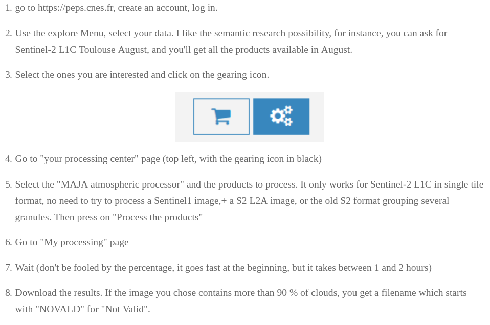
federico gonzalez alonso <fgainia@gmail.com>
9:27 PM (18 hours ago)
to info
http://www.eumetsat.int/website/home/News/DAT_3008837.html
https://eoportal.eumetsat.int/userMgmt/login.faces?goto=http://coda.eumetsat.int/#/home
Playground
Scihub
https://scihub.esa.int/dhus/(creo que ya no va)- https://scihub.copernicus.eu/dhus/#/home
- alobo y el de siempre sin numeros
- QGIS http://carbajallosa.blogspot.com.es/2016/01/descarga-libre-de-imagenes-del-satelite.html
- non-interactive
- https://scihub.copernicus.eu/twiki/do/view%20SciHubUserGuide/5APIsAndBatchScripting#Download_full_product_from_its_U
- wget --no-check-certificate --continue --user=alobo --password=oufregit "https://scihub.copernicus.eu/dhus/odata/v1/Products/S2A_OPER_PRD_MSIL1C_PDMC_20151216T224750_R097_V20151216T162424_20151216T162424.zip"
- http://krstn.eu/download-sentinel-images-with-python/
- http://gis.stackexchange.com/questions/119244/how-to-download-products-from-esas-scihub-using-odata-protocol
Sentinel_download.py
- https://github.com/olivierhagolle/Sentinel-download
- (Note: exists also for Landsat https://github.com/olivierhagolle/LANDSAT-Download)
- list for Inti site after 2016-01-16 and before 2016-01-31
- download (can be interrupted)
- Sentinel_download.py --help
- See http://forum.step.esa.int/t/apihub-automatic-download-for-s2-tiles/1369/11 for granules
- watch http://forum.step.esa.int/t/display-grid-of-granules/1537
- try downloading JP2 @s2
- try downloading one single granule (tile) @s2
- No funciona (zips de 0 bytes)
- python Sentinel_download.py --lat 42.3308278 --lon 0.9949278 -a apihub.txt -d 2015-12-02 -f 2015-12-04 -s S2 -t 31TCG
- http://forum.step.esa.int/t/download-tiles/1687
- mirar con qgis @s2
- Report problem with date range (wait for Maria to inform about naming convention) @s2
===============================================
S2A_OPER_PRD_MSIL1C_PDMC_20151202T224345_R008_V20151130T105641_20151130T105641.SAFE
https://scihub.copernicus.eu/apihub/odata/v1/Products('b9019806-f6a5-47ce-9fe5-bfabb06d7d60')/\$value
cloud percentage = 1.33 %
===============================================
python Sentinel_download.py --lat 42.3308278 --lon 0.9949278 -a apihub.txt -d 2015-11-20 -f 2015-12-02 -n -s S2 -w /home/alobo/Sentinel2/Montcortes
no result
Generation time instead of date of data taken (acquisision time)???
Download for El Gobierno (Nicaragua)
- list for Inti site after 2016-01-16 and before 2016-01-31
- download (can be interrupted)
Download for La Bertolina
python Sentinel_download.py --lat 42.09896 --lon 1.66155 -a apihub.txt -d 2015-01-16 -f 2016-02-19 -n -s S2
Download for Estany de Montcortés
- listing:
python Sentinel_download.py --lat 42.3308278 --lon 0.9949278 -a apihub.txt -d 2015-09-01 -f 2016-02-25 -n -s S2
- downloading:
python Sentinel_download.py --lat 42.3308278 --lon 0.9949278 -a apihub.txt -d 2015-11-20 -f 2015-12-03 -s S2 -w /home/alobo/Sentinel2/Montcortes
Downoad for Isla Decepcion
python Sentinel_download.py --lat -62.956050 --lon -60.643152 -a apihub.txt -d 2016-03-23 -f 2016-03-23 -s S2 -w /home/alobo/Sentinel2/Decepcion
python Sentinel_download.py --lat -62.956050 --lon -60.643152 -a apihub.txt -d 2016-03-23 -f 2016-03-23 -n -s S2
Download specific tile
Individual tiles or granule can be downloaded from amazon mirror. For your tile, a link that you should follow is http://sentinel-s2-l1c.s3-website.eu-central-1.amazonaws.com/#tiles/31/T/CG/2
http://forum.step.esa.int/t/download-tiles/1687
- try wget with that @s2
PEPS
- Alternativa PEPS http://www.cesbio.ups-tlse.fr/multitemp/?p=9701
#Nicaragua
#**** products after '2016-12-05' are stored in Tiled products collection
#**** please use option -c S2ST

python ./peps_download.py -c S2ST --lat 12.44966 --lon -87.05445 -a peps.txt -d 2017-07-01 -f 2017-08-01 -nce41a0ec-5644-5023-bfc9-990e51ee82fb 2017-07-28T15:59:01.026Z disk
#S2A_MSIL1C_20170728T155901_N0205_R097_T16PDU_20170728T161200
#S2A_MSIL1C_20170721T161351_N0205_R140_T16PDU_20170721T162051
#S2A_MSIL1C_20170721T161351_N0205_R140_T16PEU_20170721T162051
#S2A_MSIL1C_20170701T161341_N0205_R140_T16PEU_20170701T162605
#S2A_MSIL1C_20170701T161341_N0205_R140_T16PDU_20170701T162605
Theia
https://theia.cnes.fr/atdistrib/rocket/#/home
https://theia.cnes.fr/atdistrib/rocket/#/search?collection=SENTINEL2
(info en https://www.theia-land.fr/en/data-and-services-for-the-land/)
equivalent to Sentinel_download.py
(Recomended for areas with Maja processing in Theia)
- theia_download.py (https://github.com/olivierhagolle/theia_download)
Download for La Bertolina
#Bertolina:
python /home/alobo/theia_download-master/theia_download.py -lon 1.65482 -lat 42.09408 -c SENTINEL2 -a config_theia.cfg -d 2017-07-01 -f 2016-07-31
python /home/alobo/theia_download-master/theia_download.py -n -lon 1.65482 -lat 42.09408 -c SENTINEL2 -a config_theia.cfg -d 2017-07-01 -f 2016-07-31
Theia Products
- https://www.theia-land.fr/en/product/sentinel-2-surface-reflectance/
- Full description: https://theia.cnes.fr/atdistrib/rocket/#/documents
Level 2A
https://theia.cnes.fr/atdistrib/rocket/#/documents
https://labo.obs-mip.fr/multitemp/sentinel-2/theias-sentinel-2-l2a-product-format/
https://theia.cnes.fr/atdistrib/documents/PSC-NT-411-0362-CNES_01_00_SENTINEL-2A_L2A_Products_Description.pdf
The level 2A products correct the data for atmospheric effects and detect the clouds and their shadows.
They are produced by MAJA(Formerly known as MACCS), using MUSCATE processing center at CNES, in the framework of THEIA land data center.
Sentinel-2 level 1C data are downloaded from PEPS.
The data are coded on 16bits and you have to divide by 10000 to obtain reflectances.
The No_Data value (outside the image) is -10000
see description of zip contents:
https://labo.obs-mip.fr/multitemp/sentinel-2/theias-sentinel-2-l2a-product-format/#English
FRE is flat surface reflectance (corrected for terrain)
Level 3A
https://theia.cnes.fr/atdistrib/rocket/#/documents
https://theia.cnes.fr/atdistrib/documents/THEIA-ST-411-0419[[https://theia.cnes.fr/atdistrib/documents/THEIA-ST-411-0419-CNES_01-04_Format_Specification_of_MUSCATE_Level-3A_Products-signed.pdf|-]][[CNES_01-04_Format_Specification_of_MUSCATE_Level-3A_Products-signed.pdf]]
https://labo.obs-mip.fr/multitemp/theias-l3a-product-format/
The products of level 3A provide a monthly synthesis of surface reflectances from Theia's L2A products. The synthesis is based on a weighted arithmetic mean of clear observations. (CESBIO)
The data processing is produced by WASP (Weighted Average Synthesis Processor), by MUSCATE data center at CNES, in the framework of THEIA data center. The processing chain WASP is an adaptation of the monthly synthesis chain from the project Sen2Agri, funded by ESA. This chain had been defined by CESBIO and initially developed by CS-Romania. It has been adjusted to the THEIA context by CNES.
The data are coded on 16bits signed integers and you have to divide by 10000 to obtain reflectances.
The No_Data value (outside the image) is -10000
1 = Cloud
2 = Snow
3 = Water
4 = Land
Theia's Snow data
Theia's SPOT World Heritage (OSFACO) data
Venμs data distributed by Theia
PEPS Remote (on demand) Maja processing
(Recomended for zones not included in Theia, i.e. Nicaragua or most Spain)
- https://peps.cnes.fr/rocket/#/register
- use peps_maja_process.py and peps_maja_download.py (https://github.com/olivierhagolle/maja_peps)
- from the web page (according to http://www.cesbio.ups-tlse.fr/multitemp/?p=14335)
Tiles
Worldwide
https://sentinel.esa.int/documents/247904/1955685/S2A_OPER_GIP_TILPAR_MPC__20151209T095117_V20150622T000000_21000101T000000_B00.kml/ec05e22c-a2bc-4a13-9e84-02d5257b09a8 (parece que el link ha dejado de funcionar)
- /dataext3/dataalobo/Sentinel2/S2A_OPER_GIP_TILPAR_MPC__20151209T095117_V20150622T000000_21000101T000000_B00.kml
$ ogrinfo S2A_OPER_GIP_TILPAR_MPC__20151209T095117_V20150622T000000_21000101T000000_B00.kml
INFO: Open of `S2A_OPER_GIP_TILPAR_MPC__20151209T095117_V20150622T000000_21000101T000000_B00.kml'
	  using driver `LIBKML' successful.
1: Features
2: Info
Nicaragua El Gobierno

16PDA|16PEA|16PFA
16PDV|16PEV|16PFV
Convert to shape
ogr2ogr -f "ESRI Shapefile" -skipfailures -nlt polygon S2Atiles S2A_OPER_GIP_TILPAR_MPC__20151209T095117_V20150622T000000_21000101T000000_B00.kml
You get 2 shapefiles within S2Atiles, Features and Info
As far I can tell, Info is empty
In the following way, you get Features renamed to S2Atiles:
ogr2ogr -f "ESRI Shapefile" -skipfailures -nlt polygon -nln S2Atiles S2Atiles S2A_OPER_GIP_TILPAR_MPC__20151209T095117_V20150622T000000_21000101T000000_B00.kml
Ignore the error (it tells that cannot overwrite layer S2Atiles with the contents of Info, which is ok)
It would be neater selecting layer Features with -geomfile, but it did not work and it is irrelevant for us
- file: /dataext3/dataalobo/Sentinel2/S2Atiles
Subset and convert to shape
ogr2ogr -f "ESRI Shapefile" -skipfailures -spat -10 30 5 45 -nlt polygon -nln IberiaS2Atiles IberiaS2Atiles S2A_OPER_GIP_TILPAR_MPC__20151209T095117_V20150622T000000_21000101T000000_B00.kml
Selectioner tiles
http://www.cesbio.ups-tlse.fr/multitemp/?p=7077#comment-73279
Download only the S2A tiles you need from Scihub
14/03/2016Olivier Hagolle 3 Comments
J'ai adapté mon outil de téléchargement de données Sentinel-2, pour que l'on puisse ne télécharger qu'une tuile à la fois, au lieu de télécharger toutes les tuiles du produit. Ce n'était pas simple, parce qu'il faut récupérer les données fichier par fichier et répertoire par répertoire. mais ça a l'air de fonctionner. Voici un exemple pour télécharger systématiquement la tuile de Toulouse.
python Sentinel_download.py --lat 43.6 --lon 1.44 -a apihub.txt -o 51 -t 31TCJ
Pour plus de précisions et d'exemples, consulter le "Readme".