Laboratory of Hyperspectral Imaging
Presentation

The Laboratory of Hyperspectral Imaging (HSI Lab) is a recent GEO3BCN facility aimed to:
- Participate in research projects in which the analysis of hyperspectral imaging will have a significant impact.
- Provide support to other research, education and commercial activities.
HSI Lab presentation 2021-01-20
People
- Dr. Agustín Lobo (Agustin.Lobo@geo3bcn.csic.es)
- Dr. Jordi Ibañez (jibnaez@geo3bcn.csic.es)
- Dr. Robert Oliva (roliva@geo3bcn.csic.es)
Imaging Spectroscopy
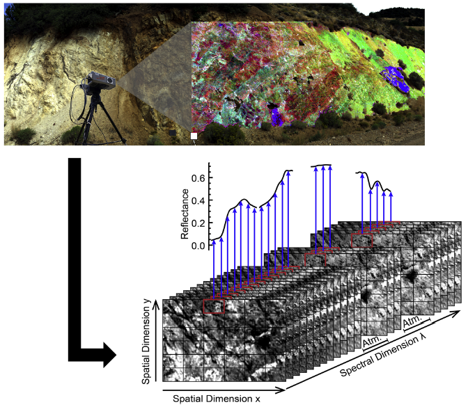
Hyperspectral images produced by imaging spectrometers are 3D arrays in which each voxel holds a radiance spectrum that is processed to reflectance. Acquisition of single reflectance spectra with point spectrometers in the visible, near-infrared, and short-wave infrared wavelength domains (400 – 2500 nm) is a relatively simple and non-invasive technique that has been used in the laboratory and the field for decades ago. The particular optical and electronic properties of each material result, under illumination, in specific spectral features that are often diagnostic of given minerals and rocks, although the influence of variations in illumination and viewing geometry, the macro-structure of the sample, and the presence of mixtures in the field-of-view, tend to reduce the diagnostic power of reflectance spectra.

- Field probe for point spectrometer [1];
- Main processes related to reflectance spectral features [2];
- Examples of more detailed spectral features [3]
Extending point readings to a hyperspectral image has several advantages. First, it is possible to improve the accuracy of the identification by adding image features, such as texture, to the spectra. Second, the 2D result allows considering the spatial distribution of different materials in the imaged scene. This is particularly important when working at an scale in which the relative position of materials is relevant. Finally, in case of a crude or doubtful identification, being able to delimit a given uncertain material facilitates an accurate sampling for complementary techniques such as x-ray diffraction (XRD) or x-ray fluorescence (XRF). Until very recently, most hyperspectral images were remotely acquired from airborne sensors and a few satellites, but as hyperspectral imaging systems become more portable and widespread, close-range hyperspectral imaging becomes more common in laboratories and some industrial premises. Ground-based and drone-based hyperspectral systems are most recent developments and offer imagery at unprecedented scales and view angles.
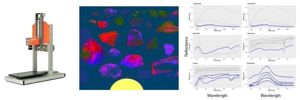
 Laboratory scanner, false color of scanned samples, and spectra of selected locations on the samples.

Ground-based acquisition of a hyperspectral image and its schematic representation [4]
[1] https://analytik.co.uk/product/portable-vis-nir-spectroscopy-terraspec
[2] Tempfli, K, G.C Huurneman, W.H Bakker, L.L.F Janssen, W.F Feringa, A.S.M Gieske, K.A Grabmaier, C.A Hecker, and J.A. van der Horn. Principles of Remote Sensing: An Introductory Textbook. Enschede: ITC, 2009.
https://research.utwente.nl/en/publications/principles-of-remote-sensing-an-introductory-textbook-4
[3] Clark, R.N.; King, T.V.; Klejwa, M.; Swayze, G.A.; Vergo, N. High Spectral Resolution Reflectance Spectroscopy of Minerals. Journal of Geophysical Research: Solid Earth (1978–2012) 1990, 95, 12653–12680.
[4] Krupnik, Diana, and Shuhab Khan. “Close-Range, Ground-Based Hyperspectral Imaging for Mining Applications at Various Scales: Review and Case Studies.” Earth-Science Reviews 198 (November 2019): 102952. https://doi.org/10.1016/j.earscirev.2019.102952.